Tactile street crossings

Street crossings are an important concept for any child to learn, but even more so for children who are blind or have low vision. Orientation and mobility instructors also require tactile and high contrast mapping tools to help blind adults learn specific street crossings that they will need to navigate independently. Below, we have listed some resources that may be helpful.

Our Inclusive Technologies team at Monash University is working to create additional resources. Please contact leona.holloway@monash.edu if you would like to share your ideas about what you think is needed.

Tactile intersections by Lighthouse for the Blind

Lighthouse for the Blind teamed with an orientation and mobility instructor to create a collection of swell paper diagrams depicting common intersections. They are designed to teach about intersection designs, traffic flow and street crossings.

Swell paper diagrams showing intersection types, cross streets, T-intersection, etc.

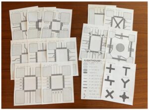
Cost is US$85 for a pack of 13 diagrams from the Adaptations store.

Tactile Town

Tactile Town is a kit of felt pieces depicting roads, dividing lines, grass, buildings, and more. It is best suited for teaching concepts of streets crossing to young children, who can create their own street scenes and learn through play.

TactileTown_Kit_APH

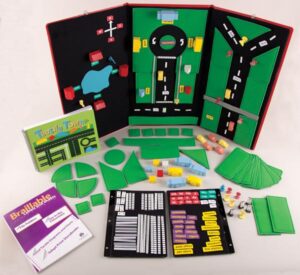
Cost US$470 from the APH shop.
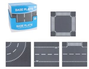
Lego

Lego is a popular building tool that can be used to create simple square street scenes including people, vehicles, street signs and traffic lights. Base plates are available with a straight road, T-intersection, cross roads or curved road at a cost of around AUD$18 for a pack of two bases.

Lego base plates with roads, traffic lights, street lights and other street scene items

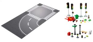
In Australia, Target also sells Lego-compatible base plates with the same variety of road crossings for $5 each.

Lego-compatible base plates with cross intersection, curved road, straight road or T-intersection

Road Tape

Create your own crossings for children to play and learn using plastic road tape on a contrasting colour and texture, such as a pale coloured fabric mat.

Wide black tape with white centre lane and zebra crossings. Shown with wooden cars with simple wooden cars with wheels.

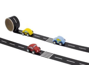
Sold locally as a roll of 8m of tape and one car for just over AUD$10 from Wombats or Little Online Shop.

Waytoplay rubber road segments

Waytoplay rubber road segments are thick, providing tactile contrast, and black with white line markings, providing realism and strong visual contrast. Segments can be bought in packs and combined to create an array of different crossings.

black road segments with white lane markings. They include curve, cross road, straight and straight with zebra crossing

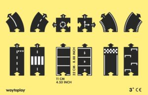
Cost AUD$65-$200 per set.

Other DIY methods for creating tactile graphics

Refer to our page on quick tips for creating tactile graphics by hand for a range of methods and materials that can be used to create handmade tactile graphics, including methods that blind people can use to draw their own street maps.

Accessible maps of the Brisbane Museum District

While at the 2019 Round Table Conference in Brisbane, a group of attendees (touch readers, family members and accessible format producers) took a short excursion to explore the accessible maps of the museum district in South Bank.

We found several wall-mounted print/braille maps along with a large table-top model, located on the Grey street side of the State Library. It was wonderful to experience these inclusive accessibility measures in public spaces.
3 photographs: walking with dog and cane; clear print and tactile map; large 3D model of buildings and roads

Do you know of any similar maps or models in your area? Please let us know!

Inclusive Maps at the Melbourne International Flower and Garden Show

The Melbourne International Flower and Garden Show took place at the Carlton Gardens from Wednesday 27 to Sunday 31 March 2019. Guide Dogs Victoria partnered with Kangan Institute and Bendigo TAFE to sponsor the Rob Waddell Show Garden and host their own sensory garden, featuring scented plants, auditory cues, beacons and braille. As an added tool for accessibility and inclusion, researchers from Monash University’s Inclusive Technology group created 3D printed maps of the Carlton gardens, the Rob Waddell Show Garden and the Guide Dogs Victoria sensory garden. Visitors who were blind or have low vision were able to use the maps to gain a better understanding of their surroundings.

3D printed map of the Carlton Gardens and Exhibition Building, placed in a garden with herbs and bee hives

Anuradha’s achievements in accessible mapping

With the holiday season around the corner, we had another reason to celebrate this week. PhD candidate Anuradha Madugalla has been working on the automated conversion of house floor plans to accessible formats: a written description, tactile graphic and interactive GraVVITAS diagram with audio labels on the iPad. Her work has resulted in two major publications:

  • Madugalla, A., Marriott, K. & Marinai, S. (2017). Partitioning Open Plan Areas in Floor Plans. 2017 14th IAPR International Conference on Document Analysis and Recognition (ICDAR).
  • Goncu, C., Madugalla, A., Marinai, S. & Marriott, K. (2015). Accessible On-Line Floor Plans. WWW ’15 Proceedings of the 24th International Conference on World Wide Web.

Anuradha has submitted her thesis and is looking forward to a well-deserved break before pursuing work goals. We wish her all the very best.

Anuradha (3rd from the right) with staff and students from Monash FIT's Computer-Human Interaction & Creativity group.
Anuradha (3rd from the right) with staff and students from Monash FIT’s Computer-Human Interaction & Creativity group.